OT: Nothing for you here: Move on: Darwin-Ambon

This year, as in the past, no BCCs are taking part in the Darwin-Ambon Race.

But Sumio Oya, known to many here including from his days as President of Sam L. Morse Co., is crewing aboard s/v Nirai,an Adams 40 run by Shige & Riri Asao. Start date was the Saturday just past.

Participation in the Darwin-Ambon Race is one of the easiest ways to sail through the core of the Great Archipelago, the biggest island group on the planet (divided among a few different jurisdictions, including Indonesia, Malaysia, Philippines, etc).

The Darwin-Ambon route is a tiny part of what’s now called the Sail Indonesia route. See the yellow route on the chart at: Sail Indonesia

Doing the paperwork to sail through Indonesia can be a pain (Zygote sailed the route eastabout back in 2005 - we did the paperwork ourselves, so you could do it yourself, but if you’re voyaging westabout, participating in Darwin-Ambon does the paperwork for you painlessly and schedules you at the right season, with the bonus of some support).

A couple of boats taking part this year have had the usual problems when broad reaching and running: torn spinnakers, failed steering.

I’ve no reports from Nirai yet. After a day or so of strong wind and fast sailing, winds for the fleet are now dropping. The lead yacht is now only 30 nm from Ambon.

A couple of the other boats are reporting positions via Spot. And the Dinah Beach Cruising Yacht Association (the organiser at the Australian end) has updates and links to the SPOT data at http://www.darwinambonrace.com.au/

Sail Indonesia is also posting updates, at Sail Indonesia

Cheers

Bil

Hi Bil , Thank You for that up-date , we are looking forward to the fleet arrival in Singapore.

Gosh , how many times do you think that Sumio , sailing a BCC , would have smoked the fleet of crab crushers ?

Will you be able to report more of the event as the fickle winds allow ?

Douglas

Sumio called me before he left for Oz, said he would pobably try to update the Nirai blog when he could. However, he has not posted yet.

http://www.marinersblogs.net/?a=blog&id=81

Several yachts had made port in Ambon before dawn this morning. The Indonesian government motor vessel (a fisheries inspection vessel) made port in Ambon at 04 hours local and reported 3 yachts already at anchor then.

Still no word from Nirai. But my understanding is that Aso san is a careful cruiser, so I do not imagine that he would have risked tearing a spinnaker in a devil-take-the-hindmost downwind race. I instead expect that Nirai sailed with care and attention, enjoying their crossing of the Arafura Sea and the Banda Sea.

Cheers

Bil

All the boats in the Racing Division have finished.

Quite a few boats in the Cruising Division, including Nirai, have not yet entered Ambon harbour.

But there are no concerns about the safety of Nirai or other boats in the cruising division.

Update 29 July 14 hours local time: Nirai has anchored at Banda. Several of the boats in the Cruising Division opted not to run non-stop to Ambon, but to go to Banda first and then to Ambon. Nirai is among that group.

Cheers

Bil

Hi Bil , I took a look at the list of the 100+ participants, and only recognized one name.

That was # 29 , S/V Convergence, a Wylie 66. The owner/Captain says : Randy Repass .

Being from the San Francisco Bay area, I recognize that name as the man who started West Marine , in Sausalito, selling his dad’s rope, out of his garage, way back in the early 80’s .

I am sure that his boat is all tricked out from the best that West Marine has to offer, and more.

Wonder if he would be interested in opening a West Marine store, here in Singapore, or how about Penang, too ?

Douglas

For those who haven’t yet discovered that the Banda island group is one of the magic places in the world and that cruising is about the only way to get there:

  • Banda is the natural origin of nutmeg

  • the Portuguese and then, in their turn, the Dutch East India Company (VOC) loved their ability to control a natural monopoly of nutmeg to the rest of the world, to the point that the VOC killed most of the locals and repopulated the islands with other people that the VOC thought might be more amenable to cultivating nutmeg for the VOC

  • see the Wikipedia page at http://en.wikipedia.org/wiki/Banda_Islands (which also tells the story of the link between the Banda islands and a big chunk of New York City!

  • Nirai is anchored around 4?32.61’S 129?53.27’E.

  • see the attached chartlet; depths in metres; green = coral; blue = < 10 m depth; Pulau = Island; Besar = Great (so Pulau Run == Run Island; Pulau Banda Besar = Greater Banda Island). And yes, the Banda Sea just S of Pulau Banda Besar is 2,000 metres deep. Pulau Banda Besar is about 6 nm long from tip to tip (straight line distance, to give you an idea of scale).

Cheers

Bil

I’ve had no further news from Sumio and Nirai. But I think it’s safe to guess that Nirai is either at anchor in Ambon or on passage from Ambon to the tip of the SE leg of Sulawesi (aka Celebes).

The passage from Ambon to the tip of the SE leg of Sulawesi will take Nirai across a famous stretch of the Banda Sea: the stretch that includes the so-called ‘Indonesian through-flow’, the flow of water from the Pacific Ocean into the Indian Ocean that is part of the globe-circling ‘conveyor belt’ of ocean flow.

The ‘Indonesian throughflow’ is not only part of the the global ocean conveyor belt. It’s the migration path of the big whales. And the Yankee whalers of the early-19th century - the people immortalised in Melville’s ‘Moby Dick’ - worked the area.

And Nirai is passing through Wallacea, the transition zone between the ecozones of Asia and Australia. To the west of the Wallace Line (proposed by Alfred Wallace, who was one of the key proposers of the theory of biological evolution that is today better known as associated with Charles Darwin) are Asian plants and animals. To the east, are species of Australian/Gondwanaland origin. Only a few species (bats, humans and the species they carried as part of their agricultural tool kit) are found on both sides of Wallacea.

As Nirai moves further E, she approaches the world-wide center of coral reef diversity. Depending on which coral expert you last met, the center of coral diversity is somewhere around the N coasts of Kalimantan and/or Sulawesi.

Asia is, as you’ve seen in reports of flooding rain in Pakistan, Thailand, China, and Korea, having a strong and wet monsoon this year. S of the Equator, the winds are reliable SE in the 15 - 20 knot range. Some thunderstorms with heavy rainfall, but not many of the nasty >40 knot squalls that are typical of a weak monsoon.

So Nirai on her passage from Ambon to SE Sulawesi, and then on further W to the SW leg of Sulawesi and the S coast of Kalimantan (aka Borneo), is likely to be broad reaching or running.

Cheers

Bil

Hello:

I Just heard from Sumio:

I am at the Wakatobi at Wangi-Wangi Island since 8/9.
We left at Darwin Australia on Jul. 24th and sail up north for 530 nm to Banda Island arrived on 7/27 then Anbon (130nm north west) 8/1,
Well, Joined Sail Indonesia is pretty good deal. So many event at each anchorages with show, dinner party, etc…
I enjoy very much this cruising so far. These event tells us there are so many different culture in Indonesia.

We are planning to stay here till 17th which is Indonesia’s Independence day then move down to near by Island to rest then sail down to Flores Islands, Comdo Island, Bali Island (mid Sept) and so on…

I can not use SPOT yet. But I put my log in the computer so, after I goes back to Japan I will make this cruising detail.

Keep in touch,

Sumio

Hi John, Hi Bil,

I am now at Wakatobi anchorage on Wangi-Wangi Island…South East of Sulawsi Island.

We left Darwin on 7/24 and arrive Banda on 7/27 and spent few days there then sail to Ambon.

Banda has small village with Dutch old Fort build in 1611. Anchorage in banda was very deep,30~40 metres (over 100’) so we have to use all chain anchor road.

Ambon is a big city with lots of mess especially market area. You can find most of the stuff for living there. Sail-Band held few events for us and it was wonderful experience. Our captain Sige was invited the dinner part held by Indonesian President who just visited Ambon.

Most of the Indonesia is enjoying the dry season but Amon is the middle of rainy season and we had very strong continuous rain for 5 days! We were so happy to leave Ambon on 8/5.

We arrive Wakatobi on 8/7. Entrance to the anchorage is very shallow and we can enter only high tide.

Indonesia is Muslim country and Ramadan started on 8/12. Even on anormal day they pray 5 time a day include mid-night, 4 in the morning. During the period of the Ramadan, they added 2 in the morning with lots of song!!! Cruisers can not sleep at night. How the locals can do the business, or work during day time?

Our plan is leave here on 8/17 and sail down to Flores Island via small atoll near Wangi-Wangi Island and rejoin Sail Indonesia. We then sail to Komodo Island, Lombok Island, Bali Island, then Kalimantan Island, Beliting Island then Bintan…

There is no good Internet connection here (Banda, Ambon, Wakatobi) I think we can get good one at Bali hopefully.
We think we will be in Bali in mid Sept.

Sumio

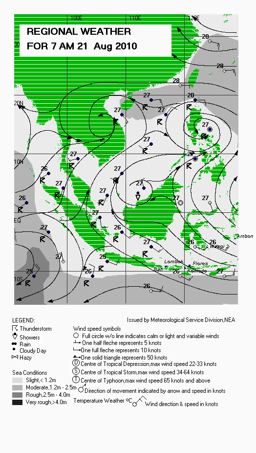
On the attached graphic, wxchart21Aug10c.gif, I’ve tried to mark the locations Sumio mentioned in his last post:

. Ambon - Nirai arrived in Ambon at the end of July 2010;

. Wangi2 (an abbreviation for Wangi Wangi) - where Nirai arrived on 7 August;

. Flores (a large island, on which fossils of Homo floresiensis, a human species replaced by Homo sapiens just 12,000 years ago, were found in 2003);

. Komodo (with the neighbor island of Rinca, the homes of the eponymous dragons);

. Lombok island; and

. Bali (I’ve placed a blue blob at Denpasar, the location of Bali Marina).

The graphic, before I defaced it, is a small scale chart of surface streamlines in the western portion of the Great Archipelago. Wind barbs accompany the surface streamlines. The numbers are temperatures in ?Celsius.

The National Environmental Agency of Singapore produces this graphic, the Regional Weather Chart, as a service to mariners. You can see the latest Regional Weather Chart (RWC) at http://www.weather.gov.sg/wip/c/portal/layout?p_l_id=PUB.1023.8

In the tropics, atmospheric pressure charts with isobars have little value. Surface streamlines, based on winds at an altitude of 10 metres are the answer.

				-- 

What I call the western portion of the Great Archipelago suffers a crisis of identity.

Much of that crisis of identity is associated with a political crisis of identity in each of the nation-states in the region and in the attempts to craft a regional political entity.

Just the western portion of the Great Archipelago is divided amongst Burma (or is it Myanmar?), Thailand (or is it Siam?), Malaysia, Singapore, China, Brunei, Indonesia, Timor Leste, Philippines, and Taiwan (or is it Republic of China?).

[A totally unrepresentative government changed the colonial name ‘Burma’ to Myanmar; not all members of the international community have accepted that name change. The 1939 name change from Siam to Thailand has been reversed once, reinstituted once, and is still resisted by many of the non-Thai ethnics. Malaysia is hopelessly divided along ethnic lines. And so it goes …]

Professional meteorologists call it the ‘Maritime Continent’. A good name, even it embodies a contradiction.

Others call it ‘Maritime Southeast Asia’, tying it specifically to the southeastern corner of Eurasia and specifically to the lands between the two great civilisation centres of China and India (and hence the moniker ‘Indo-China’, which some think of as limited to the former French colonies of Vietnam, Laos, and Cambodia). Since several of the cultures in that area developed civilisations independently of China and India, and continue to assert their independent identity, they are not too fussed with being submerged as just ‘Indochina’ or being other than the centre of the world. The Bugis, who not too long ago ran the biggest fleet of sailboats on the planet and operated trade sailboats from China to Australia and west to India, from their homeland on the southwest leg of Sulawesi, sure don’t see themselves as being on the southeast periphery of anywhere.

One yachting entrepreneur, frustrated that the world’s best cruising grounds were not delivering wealth to him, coined the term ASEANarean. That’s splicing the ending from Mediterranean to ASEAN, the joke of a regional political entity (Association of South-East Asian Nations) that survives only because no one has challenged it. The new word has not won any applause, just like ASEAN, but one marina promotes itself at ‘the premier marina in Aseanarean’. And it’s a pleasant marina, if you can afford the dock fees.

			--

Roger Olson, the great BCC owner, former Sam L. Morse Co. president, and all-round guru, sailed Xiphias into the western portion of the Great Archipelago three decades ago, making him the great pioneer (yet again!). Roger reckoned the cruising coast between Pangkor (Malaysia) and Phuket (Thailand) was one of the most beautiful he’d seen on the planet. It’s changed a bit since then, but it’s still pleasant. Roger enjoyed cruising through Indonesia and fondly remembers anchorages off villages in the outer, less-developed, islands. Roger sold Xiphias to Chris Edwards, who cruised and raced her in the waters from Singapore to Burma. Mark Fuller now owns Xiphias and can speak for himself about the region.

Meryl and I brought Zygote into the region in 2001 and enjoyed cruising the Malacca Straits from Singapore to Phuket. We based ourselves in Penang, Malaysia, and several times verified Roger’s observation about the stretch from Pangkor to Phuket. In 2005-06 we cruised from Singapore through Indonesia to the east coast of Australia.

Douglas Walling sailed Calliste into the region in 2002 on a long voyage from east coast Australia through Indonesia to Singapore and beyond, taking him into Malaysian and Thai waters. Douglas didn’t have the best introduction to the region: he arrived off Bali just as a bunch of crazy young guys exploded bombs in the tourist district. In December 2004, a tsunami wave train entering an otherwise safe marina in Langkawi, Malaysia, caused damage to Calliste. Douglas and Calliste have largely recovered from that disaster. Douglas, Calliste, his wife Lang, and Lang’s sailboat, are currently based in Singapore.

Cheers

Bil

For those of you that are more inclined to understand geographical portrayals, attached in a satellite map with place markers.

These markers represent the island, not the specific position that Nirai has visited/will visit.

Unfortunately I don’t currently have the time to make this web interactive.

Just received from Sumio:

8/5 We left Ambon in the morning. We had too much rain in Ambon almost every day, we need sun!
Our tender was almost sunk because of overnight rain!

8/7 We see the Wangi-Wangi Island (WAKATOBI) in the dawn. we set anchor in the port at 09:00

8/8 Wakatobi’s Mayer invited us for the night event. We all thought we will get a dinner as well so everybody went the event place with empty stomach but just ceremonial dance show only till midnight! All the sailors. expectations were sunk.

8/11 Islam start Ramadan and it was so noisy all night. In next few nights we could not sleep. they pray, sing a song, and there are fireworks all night.

8/15 Again, we are all invited welcome dinner party at the resort on the other side of the island. This time, they serve us the dinner before anything so, we all have a happy face.

8/17 Today is the Indonesia’s Independence Day. Mrs Riri Asao attended an underwater ceremony of the coral beach. she told us that there were 60 divers went underwater and stayed 10m 15m 20m with special hanging pole and put each country’s flag and news crew shoot for TV.

8/18 We left Wangi-Wangi at 06:00 and heading to Houga Island which is 30 nm south east of Wangi-Wangi Island.
We anchored south east of Houga beach.
This island has an Underwater Marine Research Center and they study marine biology, especially corals.
There is one of the biggest continuous coral reefs in the world which is more that 48km long.

8/19 We just snorkeling off the beach. less than 100 m from the beach there was coral drop and we so so many corals and fishes and beautiful underwater world.

8/21 We left Houga Island in the morning and heading to Flores Island which is 26 nm south.

8/23 We put anchor in front of Teluk Lihggah, a small fishing village with good anchoring spot.
Immediately 10 or more small boat surround us out with kids on board!.
Every child with sparkling eyes and tried to communicate with us but when next big catamaran arrived they moved there, we survived.
We we strolling the village, we got nice papayas and rimes (limes!) free of charge.
Anchoring near the town or village since Ramadan, the noise (Senbayan) from the music bothered everybody.
Even this village has small music with very loud volumed PA.

8/26 So, we left there and moved to Gili Bodo which is small uninhabited island 30 nm north east of Labhan Bajo.
We anchored off the coral beach and slept like dead men.
We spent quiet peacefull days here with 2 other cruising boats.

8/26 We went with other boaters to the beach and we did nice bonfire and drinking and chatting at the beach.

8/27 We enter the city of Labhan Bajo main port.
Labhan Bajo is the main gate to the Komodo and Rinca Island, we saw the Komodo Dragon and went on a diving tour around the Komodo Island.
Here we could get all the basic provisions and water, fuel.
Anchoring inside of the port was mistake. the port is so busy with tour boats, diving boats, and other cargo and fishing boats, then at night large ferry arrived.

8/28 We put all the provision and fuel, water and left the port and heading Gili Laut which is north east of Komodo Island which is one of the best diving spot here in Komodo.
The anchorage is open to east and large swell is coming from the east and wind is from north so the boat rolls badly but it is a beautiful place.
We stayed till 8/30 hoping with swell would die, but boat was rolling whole time we stayed here.

8/30 We moved to Komodo’s north east cove which protected from the swells.
We went to the land in the afternoon but we could not see any dragons but we saw a family of deer.
It was so peaceful here, there is no other boats and no human here for two days with no rolling at all… good sleep.

9/1 We left Komodo north cove and heading Rinca Park entrance cove (Laut Buya) 15 nm.
When we cross the straight between Floress and Komodo we had over 3 kt of current and our compass heading was 90 degrees the GPS heading is reading 135 degrees. The Sea of Flores and Indian Ocean meet here.

9/2 We went to the park and saw Komodo Dragons which hang around the kitchen area of the restaurant.

Sumio and Nirai are docked in Nongsa Point Marina, which is on Batam Island in the Riau group of isands in Indonesia. See http://www.nongsapointmarina.com/marina.php

Nongsa Point Marina is just across the Singapore Strait, one of the busiest waterways in the world, from Singapore.

Nirai will exit Indonesia at Nongsa Point and then sail across to Danga Bay Marina, in Malaysia (dodging the cargo ships, which are usually spaced 10 minutes apart by the VTS). Danga Bay Marina is in the Johor Strait, which runs between the Malaysian state of Johor and the Republic of Singapore. See http://www.dangabay.com/en/leisure/marina-danga-bay

Sumio is aiming to leave Nirai at Danga Bay, catch a bus across the Causeway to Singapore, and fly back to Japan on October 31. He’s a heap of stories and photos to share.

Meryl and I are planning to pass through Singapore on October 30 (travelling by air); we’re hoping to meet Sumio and also Douglas Walling.

Cheers

Bil

Meryl, Sumio, and I had dim sum breakfast on Saturday 30 October in Singapore at our favorite dim sum cafe. That’s me with the ‘offical’ BCC 116 cap, Sumio with the bush hat, and Meryl in between: see SingaporeSumio.jpg.

Douglas Walling of BCC Calliste was busy with other matters on Saturday, but he had given Sumio a tour of Calliste just the day before. Sumio was, as I have always been, impressed at Douglas’s quality of maintenance and workmanship. Douglas sets a high standard for us!

Sumio showed us a selection of his excellent videos (including underwater videos down to 3 meters depth) taken during his voyage. The highlights included: snorkelling and diving on excellent coral reefs; close-up encounters with komodo dragons on Rinca Island; the pink beach (the sand of which is from red coral) on Komodo Island; art performances (song and dance, and wayang kulit/shadow puppet) on Bali; and the red apes (orang utan) at Kumai on Kalimantan.

Sumio flew back to Japan on Sunday, joining the first flight from Singapore to land at Haneda airport for 30+ years (and scored banquet catering and other freebies!).

Nirai, with Shige and Riri Asao on board will now sail NW up the Malacca Strait to Langkawi, Malaysia. She’ll make port at Pangkor Island, Penang, and Langkawi (let me remind you that Roger Olson reckoned that some of the world’s most beautiful cruising is from Pangkor, Malaysia, to Phuket, Thailand).

I expect to meet Nirai and her crew in Penang on 27-29 November.

Cheers

Bil